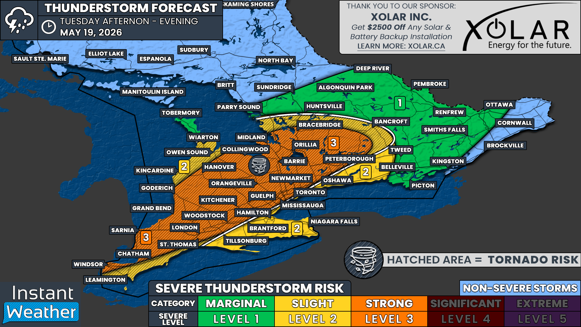
Tornado Tuesday Could Bring Damaging Storms to Southern Ontario With Strong Severe Threat
/
NOTE: YOU CAN CLICK ON THE MAP TO OPEN A ZOOMABLE IMAGE
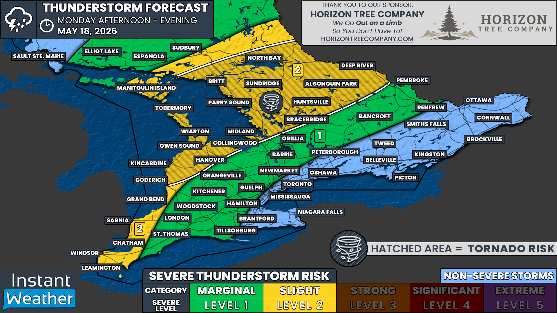
After an active, severe weather day on Monday that left widespread damage across parts of Central Ontario, especially throughout cottage country, another volatile day is shaping up across Southern Ontario.
In fact, Tuesday’s severe weather risk could end up being even stronger than Monday’s in some areas, particularly across Southwestern Ontario extending northeast toward Lake Simcoe and portions of the Golden Horseshoe.
Isolated thunderstorms are expected to develop during the late afternoon and early evening hours, bringing the potential for all modes of severe weather. This includes damaging wind gusts exceeding 100 km/h, hail up to ping pong ball size and the risk for a few tornadoes.
The primary area of concern stretches from Midland southwest toward Sarnia. Conditions in this corridor may support the development of supercells during the early stages of storm development. Supercells are rotating thunderstorms capable of producing tornadoes, very large hail and destructive wind gusts.
This early stage of the event is when the tornado and hail threat is expected to be at its highest, as storms remain isolated and are able to fully tap into the warm, unstable and highly sheared environment in place across the region.
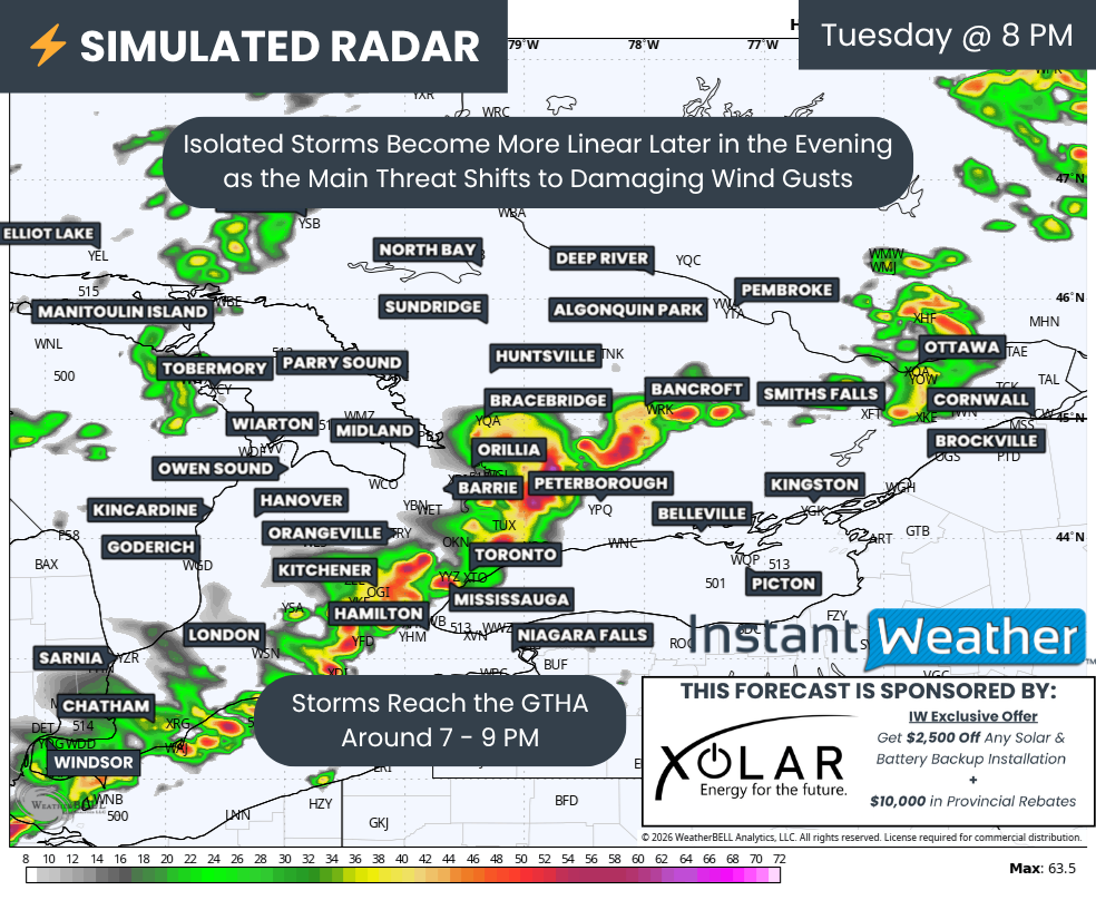
As these storms track north and east through the evening hours, they are expected to gradually transition into a more linear storm mode. In other words, the isolated storms may begin to merge together into a squall line or broken line of embedded thunderstorms as they approach the Golden Horseshoe during the early evening.
At that point, the primary threat would shift away from tornadoes and large hail and toward widespread damaging wind gusts. However, isolated tornadoes can still occur within these types of storm lines through quick spin-ups along the leading edge, even if that is no longer the dominant concern.
The severe weather threat is expected to diminish fairly quickly after sunset, likely between 9 and 10 PM, as the loss of daytime heating weakens the atmosphere’s ability to sustain intense thunderstorms.
Behind the storms, a cold front is expected to sweep through the province overnight, bringing a sharp end to Southern Ontario’s first heat event of the year. By Wednesday morning, some areas could be waking up to temperatures back down in the single digits.
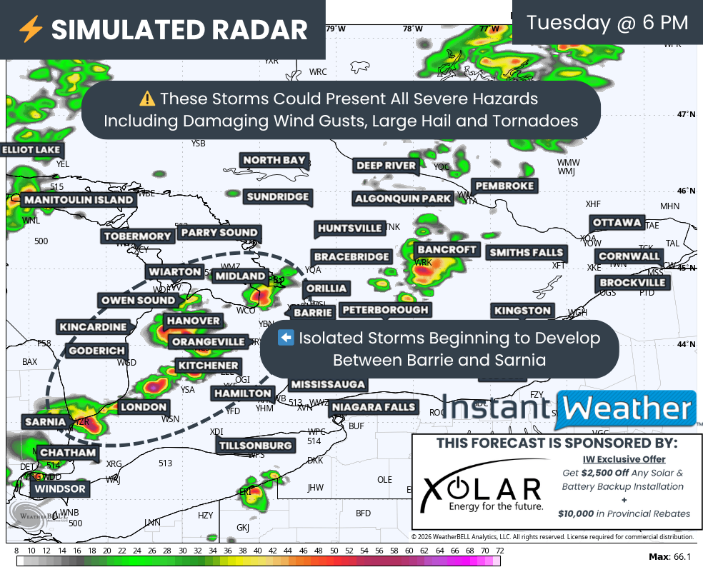
SIMULATED RADAR - MAP FROM WEATHERBELL
Based on the latest simulated radar data, isolated thunderstorms are expected to begin developing along a line extending from Midland southward toward Sarnia around 6 PM. However, that timing could still shift, especially since these setups can sometimes initiate earlier than forecast.
If storms are able to develop earlier in the afternoon, they would have access to an even more favourable environment, potentially increasing the severe weather risk.
Regardless of exactly when storms first form, the expectation is that they will remain fairly isolated for the first few hours of their lifespan as they track east of Lake Huron and northeast toward regions surrounding Lake Simcoe.
There is particular concern for the Midland to Kawartha Lakes corridor, where several model runs continue to indicate the potential for a dominant supercell to develop and track through the region.
Given that the strongest atmospheric conditions are expected to overlap in this area, any storm that develops there could become quite intense quickly, with the potential for tornadoes and very large hail.
Additional severe thunderstorms may also develop farther southwest and track through areas including London, Kitchener, Orangeville and Barrie during the dinner hour.
Farther east, a few isolated storms may also develop near Bancroft and the Ottawa Valley. However, the environment in those areas does not currently appear to be quite as favourable for widespread severe weather, so confidence in storm intensity there remains lower.
SIMULATED RADAR - MAP FROM WEATHERBELL
As the evening progresses and daylight fades, the isolated cells are expected to begin merging together into a more organized line of storms while gradually weakening as they approach the Greater Toronto Area.
These storms could certainly remain severe into the evening hours, but the primary threat would likely transition toward damaging wind gusts, which is common with linear storm events.
That does not mean the tornado threat disappears entirely though. An isolated QLCS tornado cannot be ruled out within the line as it tracks eastward through the evening.
QLCS stands for “quasi-linear convective system,” which is essentially a line of thunderstorms capable of producing brief, fast-forming tornadoes embedded within the line itself. These tornadoes are often difficult to detect and can develop with little warning.
The hail threat, however, is expected to decrease significantly by this stage of the event as storms lose their isolated structure and strong updrafts.
Overall, the severe weather risk should come to a fairly quick end shortly after sunset as the atmosphere stabilizes. While a few overnight thunderstorms may linger behind the main line, they are expected to remain below severe limits.
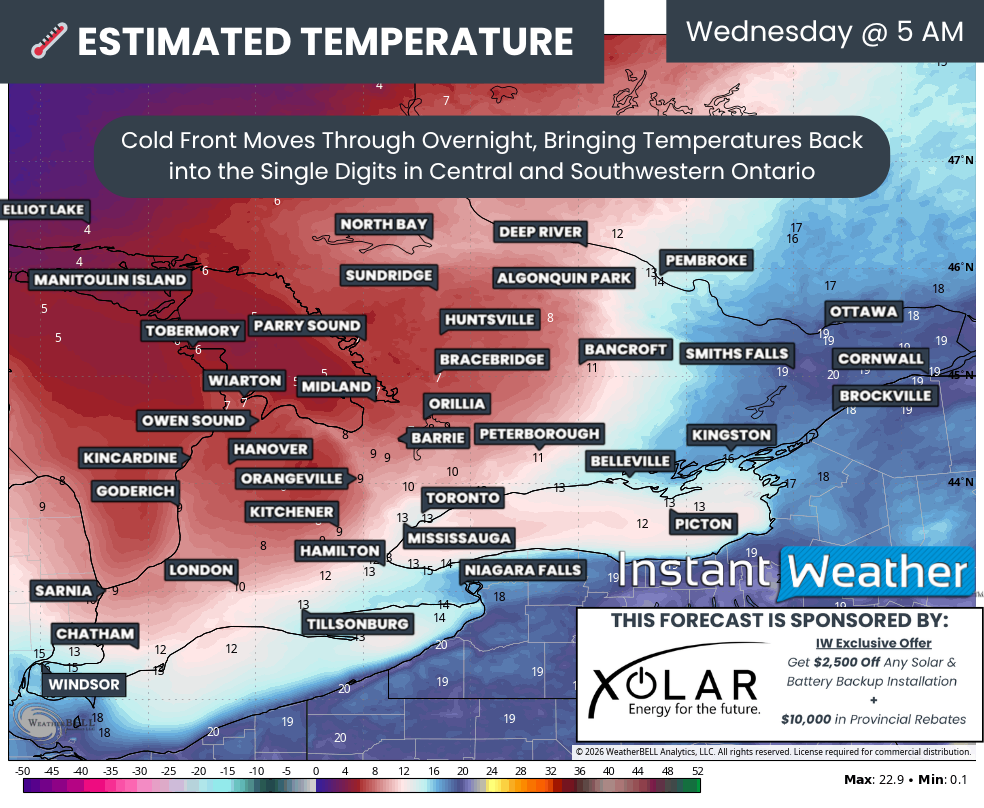
ESTIMATED TEMPERATURE (°C) - MAP FROM WEATHERBELL

Looking ahead to the rest of the week, Southern Ontario’s brief taste of summer-like weather is set to come to an abrupt end behind Tuesday night’s cold front.
Temperatures are expected to tumble overnight, with some parts of Southwestern and Central Ontario potentially waking up to single-digit temperatures by Wednesday morning. In fact, there may even be some frost risk later this week across portions of Central Ontario as cooler air settles back into the province.